
We keep two findings separate: the location of parcel 1504/6 and the interpretation of designation 20 MN. We have not established that this parcel is designated 20 MN, so we do not assign that designation to it.
Start with parcel identity
Find the parcel in official cadastral data and save its full EGiB identifier, precinct and municipality. The example documented on 23 August 2026 is 101710_2.0007.1504/6: parcel 1504/6, Kraszkowice precinct, Wierzchlas municipality, Wieluń county, Łódzkie voivodeship. That date belongs to the example’s original source check, not a claim of continuous monitoring.
The same short parcel number can exist in many precincts. Save the full boundary or a dated map showing the identifier. EGiB helps establish location and identity; it does not establish permitted development under the MPZP. A postal address is only a search aid.
Check the plan boundary against the whole parcel
Use the GUGiK planning map, then the municipality’s official planning register or BIP. The documented Kraszkowice example intersected the plan adopted by resolution III/14/2006, listed by the municipality as effective from 25 March 2007.
An intersection establishes contact with the plan’s boundary. It does not establish complete coverage or the designation of every part. Display the full parcel and plan boundary together. Mark covered and uncovered parts separately. A click in the middle cannot answer for the complete polygon.
Collect the resolution, drawing and legend
The official Wierzchlas plan register links to these distinct materials for the example:
- Resolution III/14/2006: definitions, common requirements and rules for designated areas.
- The plan drawing at 1:2000: boundaries, lines and zones.
- Its legend: the meaning of that drawing’s symbols.
Check for later amendments, supervisory decisions and court judgments affecting the area. An authentic old PDF may still be incomplete as a statement of today’s position. Read the adopted text and graphical attachment together.
Read a designation without a universal symbol decoder
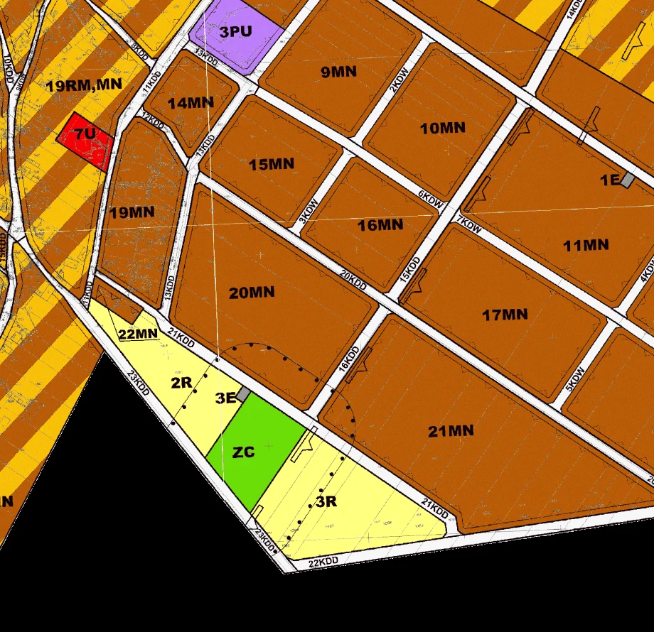
In this particular plan, the legend identifies MN as single-family residential land. Section 11 covers areas 1 MN to 22 MN and sets their principal and permitted uses. It also addresses height, roofs, building coverage, biologically active area and building lines. These are provisions of this plan, not national definitions that can be copied to another municipality.
Then return to the common provisions. Section 4 identifies binding graphical markings, including plan and area boundaries, building lines, a cemetery protection zone, a gas-pipeline controlled zone and electrical infrastructure restrictions. Sections 5–9 add common requirements concerning infrastructure, parking, protection and the environment.
Areas 20 MN and 21 MN have additional cemetery-related restrictions in section 11(3). Reading only “MN” would miss them. The example explains how to read the documents; it does not claim those areas cover parcel 1504/6.
A parcel-specific result sheet
Scroll horizontally to read every column.
| Field | What to record |
|---|---|
| Parcel | Full EGiB identifier, precinct, boundary source and check date |
| Plan | Name, resolution number, effective date and current status in the official register |
| Coverage | Whole parcel / part / not established, based on the full boundary |
| Designation | Each designation read from the drawing; do not infer it from the plan’s boundary record |
| Applicable provisions | Definitions, common rules, area-specific paragraphs, lines and overlapping zones |
| Open questions | Amendments, unclear boundaries, multiple designations or missing attachments |
Partial coverage, several zones or no MPZP
- Partial coverage: mark the planned and unplanned portions. Ask the municipality what planning route applies to the remainder.
- Several designations: read the rules for every affected area and overlay. The most convenient part does not describe the entire parcel.
- No MPZP: record where and when you checked, obtain confirmation from the municipality and establish the appropriate route for the intended project. Absence of a plan does not establish permission to build.
The end of the general-plan transition on 31 August 2026 does not itself invalidate existing MPZPs. For a new WZ application, current municipal status and transitional provisions matter. Follow the WZ decision guide rather than applying an old general statement to a new case.
If you need an official document, use the government’s MPZP extract and drawing procedure. A map screenshot is not that document.
Stop and clarify these warning signs
- A seller provides only a coloured map without the resolution or legend.
- The parcel number matches but the precinct or municipality differs.
- A plan boundary or restriction crosses the parcel, but the answer came from a single point.
- An old document is presented without checking amendments and status.
- A designation is decoded using an unrelated online table.
A useful answer can be “requires confirmation by the municipality”. Ask a designer familiar with the plan to assess the proposed building only after the complete document set and affected area are established.
Official references and using the result
- Spatial Planning and Development Act — ELI, including Articles 4, 14, 15, 20 and 30.
- 2026 consolidated text.
- Ministry clarification of 31 August 2026.
Open the parcel map to find the identifier and source links. Then use the whole-project buildability checklist; a planning designation is only one part of that assessment.